|
Title: Coal Areas in the United States
Level: Primary - Middle School ( 3 - 7 )
Time: 30 - 45 minutes depending on age/level of student
KERA Goals: 1-2, 1.3, 1.5 - 1.9, 2.1, 2.2, 2.7. 2.8, 5.1, and 6.3
Objective: Student will demonstrate knowledge of where coal is located by reading a chart.
Background Information:
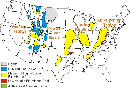
This map shows where coal is found in the United States. The information below tells which states mine coal and how much they produced in 1993.
|
1993 U.S. Coal Production, by State
(Thousand Short Tons)
| State | Total | State | Total | |
| Wyoming | 210,129 | Utah | 21,847 | |
| Kentucky | 156,299 | Arizona | 12,173 | |
| West Virginia | 130,525 | Washington | 4,748 | |
| Pennsylvania | 59,700 | Maryland | 3,355 | |
| Texas | 54,567 | Tennessee | 3,047 | |
| Illinois | 41,098 | Louisiana | 3,134 | |
| Virginia | 39,317 | Oklahoma | 1,758 | |
| Montana | 35,197 | Alaska | 1,601 | |
| North Dakota | 31,973 | Missouri | 653 | |
| Indiana | 29,295 | Kansas | 341 | |
| Ohio | 28,186 | Iowa | 175 | |
| Alabama | 24,768 | Arkansas | 44 | |
| Colorado | 21,886 |
Activity:
Fill in the names of the ten states that produced the most coal in 1993.
Can you tell from this map how many tons of coal we have in the United States? Why or why not?
What region of the country does not have coal reserves?
Does your state produce coal? Does your electricity come from coal?
Provided by the Mineral Information Institute